


Largest Geophysical Survey On National Trust Land Identifies Two Roman Villas
The largest geophysical survey ever commissioned by the National Trust has been undertaken at the Attingham Estate in Shropshire. The one-of-a-kind survey, encompassing over 1000 hectares (2,471 acres) used innovative scanning and mapping technology, and was commissioned to provide a better understanding of Attingham’s archaeological remains to help the conservation charity develop its ambitious nature recovery plans for the area.
Stripping Back the Layers at Attingham
Geophysics is a method of archaeological survey that helps to understand what is beneath the soil in a non-invasive way where potential for archaeological remains is likely, reducing the need for excavation and ground disturbance.
- When in Rome, Even the Christian Pilgrims Enjoyed the Baths of Caracalla
- Ancient Greek-Style Bathhouse for Egyptian Military Found near Red Sea
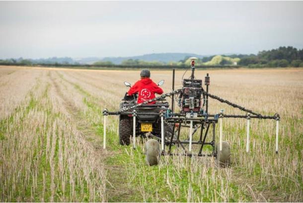
A geophysical survey at Attingham Park. (National Trust)
The Attingham Estate encompasses a portion of the buried Roman city of Wroxeter (Viriconium Cornoviorum), cared for by English Heritage, and some of the land surrounding the city.
Among the significant features identified by the survey work was evidence for what are believed to be two previously unknown Roman villas and a Roman roadside cemetery, on a road leading out of Wroxeter.
The two rural villas, (the equivalent of a large country estate) show evidence of at least two construction or occupation phases, along with floor plans with internal room divisions and associated outbuildings.
Villas of this nature in the UK were usually heated by hypocausts (underfloor heating), they often had their own bath houses and were decorated with painted plaster and mosaic floors. It is likely that both villas identified would have had similar features. Only six other Roman villas are currently known in Shropshire.

Greyscale geophysics data showing the site of a possible Roman villa on Attingham Estate in Shropshire. (National Trust)
Older Farmsteads Found
Eight ditched enclosures and associated remains, many believed to be Iron Age or Romano British farmsteads, have also been detected by the survey. These would have likely been small farms perhaps supplying food for the adjacent city, four of these were completely unknown until now.
In addition, evidence for several Roman roads to the west of Wroxeter were identified and surveys have substantially enhanced archaeologists’ understanding of the settlement activity immediately outside the defenses of the city and the changing use of the area during Roman times.
Elsewhere on the estate, new features associated with a previously known Anglo-Saxon Great Hall complex have been detected, as well as substantial evidence which furthers existing knowledge of RAF Atcham airfield, and its runways, perimeter defenses and landscaping.

An artist’s impression issued by National Trust of an iron age farmstead enclosure. (Jennie Anderson/National Trust)
Preservation Plans
Enhanced understanding of this archaeologically significant landscape provided by the survey results is enabling the Trust to progress with confidence as it plans land use changes with its tenants to help capture carbon, build climate resilience and support nature restoration in North Shropshire. Insight and learning from this work will be shared to help others sensitively plan for new woodlands in complex historic environments around the country.
National Trust Archaeologist Janine Young said:
“Attingham Estate has always been known to have high historical and archaeological significance which has now been confirmed by the largest geophysical survey the National Trust has ever undertaken. We’ve seen tantalizing hints of these remains over the years, with evidence showing up in cropmarks, aerial imagery and through small surveys and excavations. But until now, what lies beneath the surface of the ground has never fully been investigated.
This new geophysical survey has really transformed our knowledge by establishing a comprehensive ‘map’ of what is below our feet, providing us with a fascinating picture of the estate’s hidden past, revealing previously unknown sites of importance.”
Teams from Magnitude Surveys, the largest independent provider of Archaeological Geophysical surveys in the UK, used the very latest technology to carry out a magnetometer survey, which records subtle changes in the local magnetic field. This innovative surveying method enables large areas to be covered in a relatively short time, with anomalies produced when buried features exhibit different magnetic properties to the surrounding soil.
Alice Collier, National Trust Project Manager said:
“Having this detailed knowledge of the way the land has been used in the past is directly informing our plans for how the land could best be used in the future for the benefit of nature and people. The survey results are helping to influence the location and design of potential woodland and wetland projects by highlighting areas we will need to work around to protect important archaeological remains.
We are working collaboratively with our farm tenants, to look at how we can deliver changes for nature and help to mitigate and adapt to the effects of climate change whilst respecting the heritage of the landscape.”
John Deakin, Head of Trees & Woodlands at the National Trust added:
“This project will help Attingham to work with its farm tenants to identify opportunities for tree establishment across its land in North Shropshire, whilst ensuring the protection of heritage features. This has been a one-of-a kind investment for the National Trust, due to the size of the estate being mapped and the complexities presented by the rich archaeological heritage of this area of North Shropshire.
Learnings from this project will help inform the Trust’s approach to planning for nature and heritage together in different landscapes, supporting its ambitious work to improve the state of nature in the UK.”
Winn Scutt, Senior Properties Curator at English Heritage commented:
“Although we know a great deal about the city of Wroxeter in Roman times from surveys carried out in the 1990s, the wider area around the site still has much to reveal. This latest geophysical survey by the National Trust is exciting, and along with further excavation by English Heritage this July and surveys by Historic England, we are all vastly growing our understanding of this important historic site.”
The project was supported by bequests and donations to the National Trust to support its nature conservation, tree planting and heritage work.
Top image: Visualisation of one of the Attingham Roman villas. Source: © Jennie Anderson/National Trust
This article is a press release by the National Trust, originally titled, ‘Largest geophysical survey ever undertaken on National Trust land identifies what are believed to be two Roman villas’.